GCF Preparation Facility · Climate Rationale v2 · Data review
GCF Preparation Facility — data, skills & notebook review
A structured review of the data behind the Atlas Climate Rationale v2 notebook and the CGIAR Climate Data Hub’s plan to serve Green Climate Fund proposal writers — organised around the nine notebook sections in the GCF data-requirements memo, and mapped to the GCF Concept Note (v3.1) sections each one feeds.
Who this is for
The use-case task group (champion, CACC1; coordinator, CACC2; plus Brayden Youngberg and Majambo Gamoyo); the CDH technical team prioritising which datasets to bring into the Hub; and GCF proposal writers as the end users.
The goal
Compress the climate-rationale step of a GCF Concept Note / Funding Proposal from weeks to hours, while keeping methodological attribution transparent. The Togo SAT rationale (April 2025) is one illustrative example of the kind of output — a suggestion, not a prescribed standard.
How it’s organised
Four tabs: Data (this one — the nine notebook sections and their datasets), Skills (the CDH LLM-skills library and a proposed generic climate-rationale skill), Notebook (the multilateral-climate-funds pipeline idea), and GCA alignment (the Global Center on Adaptation’s parallel IFI/MDB adaptation-finance use-case and where it overlaps this one).
Decisions it informs
Which datasets the Hub catalogues first; which memo sections are in scope for v1 (August target); what to build as a reusable skill; and how to turn the climate-funds dataset into a notebook.
climateRationale notebook and its decision log. Dataset facts come from each provider’s official page, checked live on 2026-07-07 and re-checked adversarially — logged in the evidence log. Internal meeting transcripts, chats and emails are not reproduced — only short excerpts and summaries of decisions. Anything unconfirmed is marked pending, never guessed.The nine data themes at a glance
Each row is a theme of a GCF/IFI proposal and the datasets that serve it. The same data can be delivered two ways — through an Atlas-style geoselector notebook or an LLM skill that emits citable structured outputs — so this review is about the datasets, not one delivery surface. Every theme must be queryable at country + admin0/1/2 level. Click a theme to jump to its datasets.
Table 1 — Nine data themes for GCF/IFI proposal development. “Serves” = the GCF Concept Note (CN) / Funding Proposal (FP) sections each theme supports (key in the fold below the table). Status: IN CR already in the Climate Rationale notebook · PARTIAL partly present, needs additions · NEW not yet built · DEPRIORITISED in the memo but since parked. “Present” = what the live notebook does today; “Recommended” = target datasets.
| # | Notebook section | Serves (GCF proposal sections) | Status | Feasibility |
|---|---|---|---|---|
| 1 | Climate trends & projections | CN C.1 · FP B.1 | IN CR | 1 |
| 2 | Extreme events | CN C.1 · FP B.1, D.1 | IN CR | 1 |
| 3 | Crop & livestock hazard exposure | CN C.1, C.2 · FP B.1, D.1 | PARTIAL | 2–3 |
| 4 | Vulnerability & socioeconomic context | CN Exec Summary · FP D.4 | PARTIAL | 1–2 |
| 5 | NDC & NAP alignment | CN A.16 · FP D.5 | DEPRIORITISED | 3 |
| 6 | Impact potential & beneficiaries | CN A.6–A.7 · FP D.1, E.3 | NEW | 2–4 |
| 7 | Theory of change & GCF portfolio | FP B.2, D.2 | NEW | 2–3 |
| 8 | Safeguards & gender screening | CN C.4 · FP G.1–G.2 | NEW | 2 |
| 9 | Financial context & justification | CN D.1–D.4 · FP B.5, C.1 | NEW | 2 |
Feasibility 1 = easy (public, mostly integration) to 5 = hard (per-country acquisition, NLP, or new modelling). Memo priority actions: (a) extend Sections 3–4; (b) build Section 7 (GCF portfolio); (c) build the remaining NEW sections on public global datasets; (d) standardise all outputs to a common schema.
Key — what the “CN” / “FP” section codes mean
GCF applications come in two stages, each a standard template. The codes are section references within them:
- CN — Concept Note (template v3.1): the short first-stage pitch. Its sections include Exec Summary (the problem + solution), C.1 Climate change context, C.2 Proposed project/programme, C.4 Indicative safeguards profile, A.6–A.7 Estimated mitigation / adaptation outcomes, A.16 Alignment with country NDCs & NAPs, and D.1–D.4 Financing information & justification.
- FP — Funding Proposal: the full second-stage document that follows a successful Concept Note. Its section letters cover the same themes in more depth — broadly B climate rationale & theory of change, D expected performance / financing, E logic & results, G safeguards annexes (exact subsection titles per the GCF Funding Proposal template).
So e.g. “CN C.1 · FP B.1” means the section supplies the climate-context narrative needed for Concept Note section C.1 and Funding Proposal section B.1. Codes trace to the memo’s section-to-GCF mapping.
), or open the thread on GitHub (click a comment's timestamp) and drag the image into GitHub's own editor there, or use the 💬 Feedback button (its form takes file uploads). Handy for suggesting an output format or flagging an issue.💬 Comment / discuss “Sections at a glance”
Ingestion shortlist — the P1 datasets to bring in first
One consolidated do-first list for the CDH data-ingestion team: every P1 dataset across the nine themes, pulled into a single view. Quick wins (open licence + a live API or cloud-optimised endpoint) can be federated / mirrored with little work; the rest are P1 but need a licence decision or a derive-then-host step first. P2 / P3 datasets stay in each theme's table. Themes 1–2 are already held; Theme 5 is deprioritised.
Table 2 — P1 ingestion shortlist. Source: CACC1 Cesare's memo · CACC2 added by this review. Start = quick win (open + API/cloud) or resolve first (licence / derive step).
| Dataset | Theme | Source | Licence | First move (integration route) | Start |
|---|---|---|---|---|---|
| INFORM Risk | 4 · Vulnerability | CACC1 | open — CC BY 4.0 | Federate the JRC JSON API | quick win |
| FEWS NET | 4 · Vulnerability | CACC2 | open (USAID) | Federate FDW API + mirror admin2 / livelihood-zone boundaries | quick win |
| DHS (aggregate) | 4 · Vulnerability | CACC1 | open (aggregate API) | Federate the DHS Indicator API (not the restricted microdata) | quick win |
| ESA WorldCover | 6 · Impact | CACC2 | open — CC BY 4.0 | Federate the GEE / AWS COG; on-the-fly zonal stats | quick win |
| EDGAR / FAOSTAT emissions | 6 · Impact | CACC2 | open — CC BY 4.0 | Federate the FAOSTAT API (country totals) / EDGAR bulk grid | quick win |
| World Bank IEG | 7 · Portfolio | CACC1 | open — CC BY 4.0 | Federate the DDH OpenAPI | quick win |
| OECD DAC CRS | 9 · Finance | CACC1 | open — CC BY 4.0 | Federate the OECD SDMX-REST endpoint | quick win |
| OECD CRDF (Rio markers) | 7 & 9 | CACC2 | open — CC BY 4.0 | Federate via the same OECD SDMX client as CRS | quick win |
| IATI Datastore | 7 · Portfolio | CACC2 | open | Federate the Datastore API (pulls AF / IFAD / WB at once) | quick win |
| Global Forest Watch | 8 · Safeguards | CACC2 | open — CC BY 4.0 | Federate GFW API / GEE, or mirror the derived zonal stats | quick win |
| WRI Aqueduct 4.0 | 3 · Crop/livestock | CACC1 | open — CC BY 4.0 | Mirror the bulk ZIP, or derive an admin-joined bws/bwd parquet | quick win |
| AQUASTAT GMIA v5 | 3 · Crop/livestock | CACC2 | open (cite-as) | Mirror the bulk raster; pairs with Aqueduct | quick win |
| IMF fiscal | 9 · Finance | CACC1 | open via WB Data360 (CC BY) | Federate the Data360 mirror (avoid IMF's own bulk) | quick win |
| Meta RWI | 4 · Vulnerability | CACC2 | CC0 | Derive an admin table (pop-weighted zonal) then host | resolve first — derive step |
| GDL SHDI | 4 · Vulnerability | CACC2 | NC | Derive-then-host, keyed to GDLCODE | resolve first — NC |
| IPC / Cadre Harmonisé | 4 · Vulnerability | CACC1 | NC — CC BY-NC-SA | Federate the API; host derived products only (ShareAlike) | resolve first — NC |
| WDPA / Protected Planet | 8 · Safeguards | CACC1 | NC, no-redistribute | Host the derived overlay stat only — never the raw layer | resolve first — NC |
| CSPD / CSPDxCF | 8 · Safeguards | CACC1 | NC — CC BY-NC | Federate + derive the country risk tier (CGIAR sibling — coordinate with CSO) | resolve first — NC |
| IPCC EFDB | 6 · Impact | CACC1 | unclear | Derive a curated emission-factor lookup; confirm terms first | resolve first — licence |
| FAO EX-ACT | 6 · Impact | CACC1 | tool (no data licence) | Wire as a computation engine, not a hosted dataset | resolve first — it's a tool |
Reads across the theme tables below; priorities and routes are this review's assessment, open to the team's correction. Start top-down: the quick wins are the fastest path to a populated Hub.
💬 Comment / discuss “Ingestion shortlist”
1 · Climate trends & projections IN CR
Serves CN C.1 · FP B.1. Every GCF proposal opens with the climate context — a defensible account of how the climate has already shifted in the project area and how it is projected to change, from historical timeseries and future projections at admin level. The datasets must answer: what is the temperature and rainfall baseline and trajectory here, by season and scenario?
Memo requirement (verbatim)
Historical timeseries (TAVG, PTOT, by season); future projections (SSP1-2.6 through SSP5-8.5, periods 2021–2040 to 2080–2100); anomalies; warming stripes. All at administrative level.GCF Data Notebook Memo, Section 1
- Historical
- CHIRPS v3 (PTOT) + CHIRTS-ERA5 (TAVG/TMAX/TMIN) + SPEI-03/12; 0.05°; adm0 + adm1; baseline 1991–2020 (WMO); anomaly toggle
- Future
- NEX-GDDP-CMIP6, 18-GCM ensemble; adm1 only; 4 periods 2021–2100; 4 SSPs (1-2.6 → 5-8.5); baseline 1995–2014; 17–83% inter-model range
- Coverage
- served products are region = Africa (both obs & projections) — not global; the pipeline could extend but hasn't published beyond Africa
Verified against the Atlas CR data audit, 2026-07-09. Two trend/variability products (Theil-Sen slope; interannual variability) are produced but not yet wired into the production notebook.
- Sources
- NEX-GDDP-CMIP6 / CORDEX; ERA5; CHIRPS / CHIRTS
- Scenarios
- SSP1-2.6 → SSP5-8.5; periods 2021–2040 to 2080–2100
- Outputs
- anomalies + warming stripes, admin-level, with pre-computed sentence fragments
Verdict. Core capability exists and is the notebook’s strongest section. Gap is breadth of SSP/period coverage in the exposed outputs, not the underlying data.
💬 Comment / discuss “Climate trends & projections”
2 · Extreme events IN CR
Serves CN C.1 · FP B.1, D.1. A proposal must show the acute hazard is real and rising — that damaging extremes (drought, heat, heavy rain) already occur and intensify under future scenarios. The datasets must answer: how often do unusual / extreme events hit, historically versus projected, and is the frequency climbing?
Memo requirement (verbatim)
Z-score classification of unusual/extreme temperature and precipitation events; historical vs. projected frequency by scenario. All at administrative level.GCF Data Notebook Memo, Section 2
- Method
- Z-score categorisation; tails-aware (PTOT both tails, others high-only); per-hazard threshold rows
- Derivation
- computed in-notebook (client-side) from the Section 1 projections parquet; z-score vs 1995–2014; ensemble-mean only — no per-GCM classification, so tail models are masked (audit 2026-07-09)
- Source
- derived from Section 1
- Add
- historical vs projected frequency by scenario; per-GCM classification for uncertainty bands (open pipeline item)
Verdict. Matches the Togo SAT z-score approach (Fig. 5 rainfall anomalies). Note the Togo document’s own Z=1 / Z=2 labelling is internally inconsistent with its annex — resolve the threshold labels when this feeds a template.
💬 Comment / discuss “Extreme events”
3 · Crop & livestock hazard exposure PARTIAL
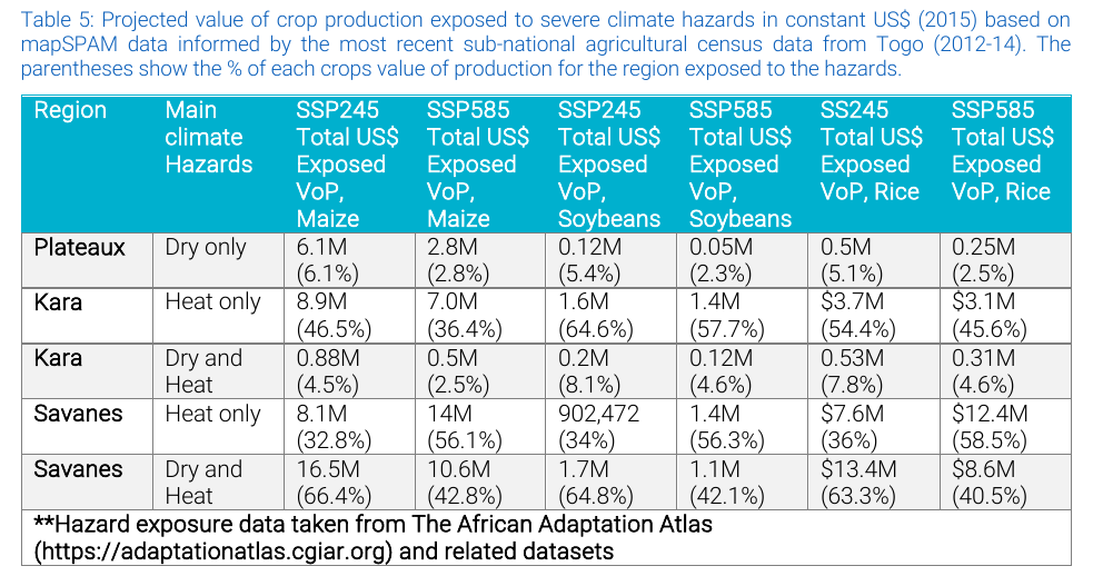
Serves CN C.1, C.2 · FP B.1, D.1. The crux of the adaptation rationale: what is at stake — the value of agricultural production and livelihoods exposed to the hazard, valued in USD (in the style of the Togo SAT Table 5 example). The datasets must answer: how much crop and livestock production value is exposed to compound hazards, where, and under which scenario?
Memo requirement (verbatim)
Production value by crop (MapSpam); crop and livestock hazard exposure (drought, heat, waterlogging combos) valued in USD by scenario. Add if possible: fisheries/aquaculture exposure, water-demand stress on irrigated systems.GCF Data Notebook Memo, Section 3
- MapSPAM 2020 · crop value
- FAOSTAT · production, prices
- GLW4 · livestock numbers
- FAO GLEAM · emission intensity
- WRI Aqueduct · water stress
- FAO FishStat · aquaculture value
- AQUASTAT GMIA v5 · irrigation extent
- Sea Around Us · marine catch value
Present in the notebook (verified against the Atlas CR data audit, 2026-07-09): MapSPAM 2020 v1r2 production value × GLW4-2020 livestock (a combined crop + livestock exposure parquet — livestock is present, not partial) × the hazard indices; Ecocrop-default thresholds. Scope: Sub-Saharan Africa only, adm1 only (the champion's "biggest limitation"); fisheries / aquaculture absent. Only the severe severity tier is live (moderate / extreme pending). Valued in nominal 2021 USD, not constant dollars.
source nex-gddp-cmip6 vs atlas_cmip6; variable vop_nominal-usd21 vs vop_intld15/usd15; model ENSEMBLEmean vs ENSEMBLE/historic; interaction filename). The constant-dollar currency fix prepped in hazards_prototype ships to keys the live notebook doesn't read. Not yet S3-verified — needs an aws s3 ls on both prefixes to confirm it's a real gap vs a stale notebook path.✅ Resolved 2026-10-07 — the audit had it backwards. Both prefixes are live; the notebook reads the canonical one (
source=nex-gddp-cmip6 … variable=vop_nominal-usd21 … model=ENSEMBLEmean, republished 2026-10-06 by scripts/r3_publish_tiers.R with an 18-GCM ensemble sidecar). The atlas_cmip6 tree is the stale 2025-06 product with the 5-GCM pin. Verified with aws s3 ls.Table 3 — Theme 3 datasets: crop & livestock hazard exposure. Source: HAVE in CDH/Atlas · CACC1 Cesare's memo · CACC2 added by this review. Priority: P1 do first · P2 next · P3 later (rubric above).
| Dataset | Source | What it is | Format & resolution | → admin | IP / licence | CDH integration route |
|---|---|---|---|---|---|---|
| MapSPAM 2020 | HAVE | Crop physical area / production / value by crop & system | GeoTIFF raster, ~10 km | zonal sum | open — CC BY 4.0 | already held (in CR) — but the run is SSA only; global MapSPAM must be run to extend coverage beyond Africa |
| FAOSTAT | HAVE | National production, area, producer prices | tabular, ISO3 × year | ISO3 join | NC — CC BY-NC-SA 3.0 IGO | already held |
| FAO GLEAM v3 | CACC1 P3 | Livestock emission intensity (+ numbers/production) — a supporting/weighting layer, not USD value or exposure | raster ~10 km + WMS/WMTS | zonal mean/sum | open — CC BY 4.0 via the GLEAM 3 dashboard Terms of Use (+ FAO Statistical Database Terms); the older restricted-use application route is superseded (verified 2026-10-07) | Federate the GLEAM 3 dashboard (animal population, products, emissions, emission intensities) or mirror its downloads; model code = un-fao/GLEAM R package (AGPL-3) |
| WRI Aqueduct 4.0 | CACC1 P1 | Baseline water stress (bws) + water depletion (bwd) — the water-demand-stress signal for irrigated systems | vector polygons (basin+province+aquifer composite) + CSV | attribute join on gid_0/1; overlay onto irrigated area | open — CC BY 4.0 | Mirror-host raw ZIP, or derive an admin-joined bws/bwd parquet |
| FAO FishStat — aquaculture value | CACC1 P2 | Aquaculture value of production (1000 USD), 1984–2021, by country (memo's "add fisheries/aquaculture") | tabular CSV, ISO3 | ISO3 join → admin0 (national only) | NC — CC BY-NC-SA 3.0 IGO | Derive-then-host parquet (normalise to ISO3+year+value) |
| FAO GLW4 | HAVE | Gridded livestock density (head/km²) by species, 2020 — open animal-numbers layer | GeoTIFF raster, ~10 km | zonal sum → head/admin; × FAOSTAT price → value exposed | open — CC BY 4.0 | already held — gives open gridded animal numbers (so GLEAM isn't needed for numbers) |
| AQUASTAT GMIA v5 | CACC2 P1 | % area equipped for irrigation — locates irrigated systems under water stress | raster 5 arc-min + shapefile | zonal sum irrigated area; multiply by Aqueduct bws | open (cite-as, Siebert et al. 2013) | Mirror-host raw; pairs directly with Aqueduct |
| Sea Around Us | CACC2 P3 | Reconstructed marine catch tonnage + landed value (sub-national / EEZ detail FishStat lacks) | 0.5° grid + EEZ polygons + API | cell → EEZ → coastal ISO3 | NC — CC BY-NC 4.0 | Federate API / derive-then-host — only if coastal/marine sub-national detail is needed |
Verdict. Highest-value theme — the hazard-exposure matrix in the style of the Togo SAT Table 5 example (see Example target output). Priorities: water-stress additions and coverage. We already hold the open GLW4 gridded animal-numbers layer, so GLEAM isn't needed to count livestock; pair Aqueduct bws with GMIA to resolve stress onto irrigated cropland. The open coverage call: served data is SSA + adm1 only (Atlas audit 2026-07-09), but the active GCF pipeline spans non-African countries (Syria, Iraq, Sri Lanka, Egypt) — so the team must decide the minimum v1 coverage, and whether to run global MapSPAM or signpost an external global product where GCF prefers one.
Overlaps → GLW4 (open animal numbers, held) supersedes GLEAM for counting livestock — GLEAM only adds emission intensity, so it belongs in Theme 6, not here. Sea Around Us overlaps FishStat — add only if sub-national/marine detail is needed beyond FishStat's national totals.
✅ Licence half resolved — coordinator, 2026-10-07: the GLEAM 3 dashboard's Terms of Use license its data CC BY 4.0 (plus FAO Statistical Database Terms), so there is no licence barrier; GLEAM is kept as a Theme 6 emission-intensity / method layer. The "what does it add" half stays with Cesare.
💬 Comment / discuss “Crop & livestock exposure”
4 · Vulnerability & socioeconomic context PARTIAL
Serves CN Exec Summary · FP D.4. The executive summary and needs case must establish who is vulnerable and why concessional GCF finance is warranted — poverty, food insecurity, water access, gender. The datasets must answer: how vulnerable are the people in the project area, on composite indices and sectoral measures?
Memo requirement (verbatim)
CR has poverty rates, GDP by sector, land use. Add if possible: composite vulnerability indices (ND-GAIN, INFORM Risk); food insecurity prevalence (IPC/CH); water stress and WASH access; gender-disaggregated vulnerability; population projections; HDI.GCF Data Notebook Memo, Section 4
- World Bank WDI · poverty, GDP
- WorldPop · population
- ND-GAIN
- INFORM Risk (+ Subnational)
- IPC / Cadre Harmonisé
- WHO/UNICEF JMP
- DHS · UNICEF MICS
- UNDP HDI
- GDL SHDI · subnational HDI
- Meta RWI · 2.4 km, CC0
- FEWS NET · admin2 food security
Present in the notebook: World Bank indicators (poverty rates, GDP by sector, land use) in Key Facts — national only.
The crux of this theme: most memo datasets are national-only (admin0) — they can only shade a whole country. Genuine subnational granularity comes from DHS, IPC/CH, INFORM-Subnational (regional coverage only), and the CACC2 additions (GDL SHDI, Meta RWI, FEWS NET).
Table 4 — Theme 4 datasets: vulnerability & socioeconomic context. Source: HAVE in CDH/Atlas · CACC1 Cesare's memo · CACC2 added by this review. Priority: P1 do first · P2 next · P3 later (rubric above).
| Dataset | Source | What it is | Format & finest admin | → admin | IP / licence | CDH integration route |
|---|---|---|---|---|---|---|
| ND-GAIN | CACC1 P2 | Climate vulnerability + readiness composite | tabular, admin0 only | ISO3 join | unclear — "free/open" but no CC text found; verify (ndgain@nd.edu) | Mirror-host (small yearly CSV) |
| INFORM Risk (global) | CACC1 P1 | Crisis/disaster risk composite (hazard·exposure·vuln·coping) | XLSX + JSON API, admin0 | ISO3 join | open — CC BY 4.0 | Federate JRC API, or mirror the annual XLSX |
| INFORM Subnational | CACC1 P2 | Same model at admin1/2 — select regions only, not global | XLSX + HDX + boundaries, admin1/2 | admin-code join | open — CC BY 4.0 | Mirror per-region; flag coverage gaps (null outside covered regions) |
| IPC / Cadre Harmonisé | CACC1 P1 | Acute food-insecurity phase (1–5) + population by phase | REST API → GeoJSON / vector tiles, subnational | area join to admin1/2 (geometry native) | NC — CC BY-NC-SA 3.0 IGO | Federate API (key) or mirror HDX CSV |
| WHO/UNICEF JMP | CACC1 P2 | Water / sanitation / hygiene coverage since 2000 | SDMX API, admin0 (urban/rural = category) | ISO3 join | NC — CC BY 3.0 IGO | Federate UNICEF SDMX, or mirror the estimates file |
| DHS Program | CACC1 P1 | Demographic & health surveys, 1500+ indicators, 90 countries | open Indicator API (JSON/geoJSON), subnational; microdata + GPS separate | breakdown=subnational → region values; join SDR boundaries | aggregate API open; microdata/GPS no-redistribute | Federate API for aggregates + mirror SDR boundaries; never mirror microdata |
| UNICEF MICS | CACC1 P3 | Child/woman wellbeing surveys (complements DHS) | SPSS microdata only, no API; region tables | derive from microdata → admin1 | restricted — no redistribution | Derive-then-host aggregate indicators only (manual pipeline) |
| UNDP HDI | CACC1 P2 | Human Development Index (health/education/income) | XLSX, admin0 | ISO3 join | open — CC BY 3.0 IGO (commercial OK) | Mirror the annual XLSX |
| GDL SHDI / Area DB | CACC2 P1 | The subnational HDI + ~130 indicators — the subnational upgrade of UNDP HDI | CSV + R API + GDLCODE shapefiles, admin1(+) | GDLCODE join | NC — non-commercial + attribution | Derive-then-host SHDI keyed to GDLCODE + ship GDL shapefiles. Fills the HDI subnational gap |
| Meta Relative Wealth Index | CACC2 P1 | ML-predicted relative wealth, 93 LMICs | gridded CSV, 2.4 km → any admin | pop-weighted zonal mean (via WorldPop) → admin0/1/2 | CC0 — public domain | Derive-then-host admin table + keep grid. Finest granularity, cleanest licence |
| FEWS NET | CACC2 P1 | Acute food-insecurity classifications + livelihood zones (IPC-compatible) | FDW REST API + GeoJSON, admin2 + livelihood zones | admin2 / LZ join (geometry native) | open (USAID; attribution) | Federate FDW API + mirror admin2/LZ boundaries — open subnational reach IPC/CH misses |
Verdict. Additions are mostly public, low-risk integrations (memo action a) — good early Hub wins. The real design decision is subnational coverage: add the CACC2 trio (GDL SHDI, Meta RWI, FEWS NET) so admin1/2 mode is more than a single country colour. Non-commercial flags on IPC, JMP, GDL are fine for GCF/non-profit use but must ride through to any LLM-skill citation.
Overlaps → GDL SHDI is the subnational version of UNDP HDI (promote GDL for admin1/2, keep HDI for the national headline); FEWS NET and IPC/Cadre Harmonisé both classify acute food insecurity (FEWS adds livelihood zones + open licence + reaches gaps IPC misses); ND-GAIN and INFORM Risk are both national composite indices — one may suffice.
💬 Comment / discuss “Vulnerability & socioeconomic”
5 · NDC & NAP alignment DEPRIORITISED
Serves CN A.16 · FP D.5. A proposal must show it aligns with the country's own climate commitments — NDC targets and NAP priorities — to demonstrate country ownership. The datasets must answer: what has the country pledged for agriculture, land use and water, and does this project deliver on it?
Memo requirement (verbatim)
Country NDC targets for agriculture, forestry, land use, water; NAP priority actions; LT-LEDS commitments; GCF country programme priorities.GCF Data Notebook Memo, Section 5
- none
- UNFCCC NDC Registry
- NAP Central
- Climate Watch
- GCF country programmes
- none new needed — the gap here is NLP text-extraction from PDFs, not more datasets; Climate Watch already structures NDC targets via API
Deprioritised — but unpacked for the dev team. The memo named this the highest-priority new section, but on 2026-04-29 the champion withdrew the automation ask (the NAP/NDC corpus — roughly a dozen documents a year — is too small to justify text-extraction automation; at most a metadata page that links out). We record the conflict rather than silently picking one. Still, if it is ever revisited, here is how each source would connect: three of the four are PDF document registries that need NLP text-extraction; only Climate Watch exposes structured NDC content via an API, so it is the pragmatic connect route.
Table 5 — Theme 5 datasets: NDC & NAP alignment. Source: HAVE in CDH/Atlas · CACC1 Cesare's memo · CACC2 added by this review. Priority: P1 do first · P2 next · P3 later (rubric above).
| Dataset | Source | What it is | Format & granularity | → connect | IP / licence | CDH integration route |
|---|---|---|---|---|---|---|
| UNFCCC NDC Registry | CACC1 P3 | Official NDC submissions — country targets for agriculture, forestry, land use, water | PDF documents per Party + registry metadata; no structured target API | download PDF → NLP-extract targets | UNFCCC terms — free download, no open licence | Federate / link; NLP extraction (non-trivial) |
| NAP Central | CACC1 P3 | National Adaptation Plans + priority actions | PDF per country | download → NLP-extract priority actions | © UNFCCC terms | Federate / link; NLP extraction |
| Climate Watch | CACC1 P2 | Structured NDC content (NDC Explorer) + GHG + pathways — the same targets, already parsed | REST API + CSV, country-structured | API query by country → structured NDC targets | open — CC BY 4.0 (Climate-Watch data) | Federate API — the structured shortcut that avoids most NLP |
| GCF country programmes | CACC1 P3 | Country programme priorities | PDF operational documents, per country | filter operational-docs by country → link | GCF terms — no open licence | Federate / link; scrape |
Verdict. Stays deprioritised (champion withdrew automation; corpus is small). If revisited, start with Climate Watch's API — it already structures NDC targets, so most of the NDC side needs no text-extraction; reserve NLP for the NAP PDFs. A metadata/signpost page linking out is the low-effort interim.
💬 Comment / discuss “NDC & NAP alignment”
6 · Impact potential & beneficiary estimates NEW
Serves CN A.6–A.7 · FP D.1, E.3. A proposal must estimate its impact — how many beneficiaries are reached and, for mitigation, how much GHG is avoided. The datasets and tools must answer: how many people benefit, and what is the tCO₂e mitigation impact?
Memo requirement (verbatim)
List of useful datasets and methods to calculate beneficiaries.GCF Data Notebook Memo, Section 6
- GLW4 · livestock activity data
- IPCC EFDB · emission factors
- FAO EX-ACT · C-balance tool
- GYGA · yield gaps
- WOCAT · SLM practices
- national census
- ESA WorldCover · 10 m land cover
- EDGAR / FAOSTAT · baseline GHG
Present in the notebook: none (WorldPop population comes via Section 4).
Read this theme as two layers: EX-ACT and the IPCC EFDB are accounting machinery, not spatial datasets — other layers supply activity data per admin unit (land-cover areas, livestock heads, holdings), which the factors/tools convert to tCO₂e for the CN A.6 mitigation claim.
Table 6 — Theme 6 datasets: impact potential & beneficiary estimates. Source: HAVE in CDH/Atlas · CACC1 Cesare's memo · CACC2 added by this review. Priority: P1 do first · P2 next · P3 later (rubric above).
| Dataset | Source | What it is | Format & resolution | → admin / use | IP / licence | CDH integration route |
|---|---|---|---|---|---|---|
| IPCC EFDB | CACC1 P1 | Methodology/DB, not spatial. Tier-1 default emission factors by IPCC category & gas | web DB + Excel export | factor lookup × activity data → tCO₂e/admin | unclear — IPCC copyright, non-commercial default | Derive-then-host a curated EF lookup (factors + category codes) |
| FAO EX-ACT | CACC1 P1 | Tool/model, not spatial. Ex-ante carbon-balance appraisal for AFOLU + value chain | Excel + online, registration | consumes admin activity data → project tCO₂e | free; no explicit OSS licence stated | Federate as a computation engine (or reimplement its coefficients); not hosted as data |
| GYGA / YPYGA | CACC1 P2 | Actual vs attainable yield + yield gap — the adaptation "close-the-gap" impact basis | tabular, by climate zone / TED (not admin) | zone→admin area-weighted crosswalk (state the caveat) | NC — CC BY-NC-SA 4.0 | Derive-then-host yield-gap figures crosswalked to admin (NC-safe evidence table) |
| WOCAT | CACC1 P2 | 2,400+ documented SLM practices — qualitative adaptation/resilience evidence | QCAT case-study records, site-level | filter practices by country/region (don't rasterise) | NC — CC BY-NC-SA 4.0 (notify wocat.cde) | Federate QCAT API, or derive a country-indexed subset |
| National census | CACC1 P3 | Ground-truth activity + beneficiary denominators (holdings, heads, population) | no common format — per-country PDF/xlsx/portal | per-country ETL → common admin schema (GAUL/GADM) | per-country; varies | Derive-then-host per country — recurring manual onboarding cost, no federation. The weak link |
| FAO GLW4 | HAVE | Gridded livestock density by species (2020) — livestock beneficiaries + enteric-CH₄ baseline | GeoTIFF ~10 km | zonal sum → head/admin (× EF) | open — CC BY 4.0 | already held — supplies the animal-numbers activity data for enteric-CH₄ accounting |
| ESA WorldCover | CACC2 P1 | 10 m land cover, 11 classes — AFOLU activity-data + land-use-change baseline | COG 10 m (GEE / AWS) | zonal area (ha) per class per admin | open — CC BY 4.0 | Federate GEE / AWS COG — no mirror needed (heavy); on-the-fly zonal stats |
| EDGAR / FAOSTAT emissions | CACC2 P1 | Baseline GHG accounting (additionality) — anthropogenic + agri/land-use emissions | EDGAR grid 0.1° + country XLSX; FAOSTAT tabular + API | zonal / ISO3 join → baseline tCO₂e by sector | open — CC BY 4.0 (avoid the IEA-EDGAR CO₂ subset) | Federate FAOSTAT API (country totals) / EDGAR bulk grid |
Verdict. Mitigation accounting (EX-ACT, IPCC EFs) is new territory — CGIAR's prior GCF work is adaptation-only, so the L2 mitigation focal point must be engaged. Build EX-ACT/EFDB as a computation layer, not a tile service. Prefer the open CACC2 trio (GLW4, ESA WorldCover, EDGAR/FAOSTAT — all CC BY 4.0) for activity data; note GYGA and GAEZ v4 are both non-commercial (derive-and-cite only). National census is the recurring manual cost — budget it.
Overlaps → GYGA and GAEZ v4 both give attainable yield / yield-gap and are both non-commercial — pick one, don't ingest both. GLW4 (held) and national census both supply livestock/holding activity data — census only where finer ground-truth is essential.
💬 Comment / discuss “Impact & beneficiaries”
7 · Theory of change & GCF portfolio evidence NEW
Serves FP B.2, D.2 (memo action (b)). A proposal must justify its theory of change with evidence and show it is not duplicating what other funders already back. The datasets must answer: what interventions are shown to work here, and what comparable food / land / water projects have the funds already financed?
Memo requirement (verbatim)
Database of approved GCF projects in food/land/water result areas (T4, T5, T6) with structured fields.GCF Data Notebook Memo, Section 7
- CACC1 MCF dataset · 5,115 GEF/GCF/AF projects (seed/spine)
- GCF project DB
- GEF projects DB
- Adaptation Fund DB
- CGIAR evidence maps
- World Bank IEG
- IFAD IOE
- OECD CRDF · Rio markers
- IATI Datastore · multi-funder feed
- GAMI · adaptation evidence
Present: the CACC1 MCF project-level dataset (5,115 GEF/GCF/AF records) is the seed/spine — see the Notebook tab.
Geometry note (all rows): these carry country as a text/ISO attribute only — no sub-national geometry, many regional/global records. For the geoselector they are admin0-after-ISO3-join; this theme is better served by the LLM-skill / citable-output route than by mapping. Keep two functions separate: comparable-projects (funds DBs) vs evidence (EGM/GAMI, feeding FP B.2/D.2 narrative).
Table 7 — Theme 7 datasets: theory of change & GCF portfolio. Source: HAVE in CDH/Atlas · CACC1 Cesare's memo · CACC2 added by this review. Priority: P1 do first · P2 next · P3 later (rubric above).
| Dataset | Source | What it is | Format & granularity | → country | IP / licence | CDH integration route |
|---|---|---|---|---|---|---|
| GCF project DB | CACC1 P2 | Approved activities: financing, disbursed, results areas, entity | Open Data Library + REST API, project-level | country field → ISO3; result-area codes → ToC | licence NOT stated (flag ARR until GCF confirms) | Federate API (key) or derive CSV — pin licence before hosting |
| GEF projects DB | CACC1 P3 | All GEF projects: focal area, agency, grant + cofinance | web DB + CSV export, no API | country/regional → ISO3 | © all rights reserved | Scrape-export → derive; seek permission or link-out + cite |
| Adaptation Fund DB | CACC1 P2 | AF projects: country, entity, amounts, sector | web DB + CSV; also published to IATI | country → ISO3 | © ARR; IATI copy open | Federate via IATI Datastore (preferred); CSV fallback |
| CGIAR evidence maps | CACC1 P3 | Evidence-and-gap maps — study corpus coded intervention × outcome (evidence, not projects) | EGM platform + CGSpace records | study→country tags (uneven) | 3ie EGM CC BY-NC-SA; CGSpace mostly CC BY | Derive study metadata for citations (respect NC/SA); harvest CGSpace OAI-PMH / REST |
| World Bank IEG | CACC1 P1 | Project performance ratings + lessons, ~11,300 assessments | Data Catalog + DDH OpenAPI, project-level ratings | country field → ISO3; ratings evidence ToC | open — CC BY 4.0 (+ WB attribution terms) | Federate DDH OpenAPI — cleanest licence of the set |
| IFAD IOE | CACC1 P3 | Independent evaluation ratings, ~315 projects, 6-point scale | Excel, annual, no API | country field → ISO3 | no explicit CC (verify with IOE) | Scrape-export → derive; cross-check IFAD IATI feed |
| OECD CRDF (Rio markers) | CACC2 P1 | Climate finance by provider × recipient × sector × adaptation/mitigation marker | Excel + SDMX API, activity-level | recipient → ISO3; Rio markers + CRS sector codes | open — CC BY 4.0 (from Jul 2024) | Federate SDMX. Best single CACC2 pick for comparables across all funders |
| IATI Registry / Datastore | CACC2 P1 | Superset of activity data from many funders (AF, IFAD, WB, UNDP) | Datastore API (CSV/JSON/XML), activity-level | recipient-country query → ISO3; some point locations | open (per-publisher, generally open) | Federate Datastore — one endpoint pulls several CACC1 funds at once |
| GAMI | CACC2 P2 | Global Adaptation Mapping Initiative — 1,682 coded adaptation-evidence articles | Zenodo CSV (DOI), literature corpus | country coded per article → ISO3 | open — CC BY 4.0 | Derive-then-host coded CSV; cite per article — the CC-BY evidence complement to CGIAR EGMs |
Verdict. Strongly overlaps the Notebook tab — the MCF dataset is the natural engine; sequence them together. Licences are not uniformly open: IEG, OECD CRDF, GAMI and the IATI feeds are clean CC BY; GCF (unstated), GEF and AF (all-rights-reserved), IFAD (unstated) and CGIAR 3ie EGMs (NC-SA) need link-out-and-cite or written permission — don't silently derive-and-host. Use OECD CRDF + IATI as the open comparable-projects backbone.
Overlaps → heavy — the held MCF dataset already unifies GEF/GCF/AF projects, and OECD CRDF + IATI supersede pulling each fund's own DB (demote the individual GCF/GEF/AF DBs to source-of-record / drill-down); CGIAR evidence maps and GAMI are both evidence corpora (GAMI is CC-BY, cleaner); WB IEG and IFAD IOE both supply project-evaluation ratings.
💬 Comment / discuss “Theory of change & portfolio”
8 · Safeguards & gender screening NEW
Serves CN C.4 · FP G.1–G.2. A proposal must pass environmental & social safeguards and gender screening — protected areas, biodiversity, indigenous lands, land tenure, SEAH risk. The datasets must answer: what environmental, social and gender risks does the project zone carry?
Memo requirement (verbatim)
Protected areas and biodiversity hotspots in project zones; indigenous territories; gender gap indices for agriculture; land tenure; SEAH risk indicators by country, Climate Security Programming Dashboard for Climate Finance (CSO).GCF Data Notebook Memo, Section 8
- none
- WDPA / Protected Planet
- IUCN Red List
- FAO SDG 5.a.x + Land Portal · replaces defunct GLRD
- OECD SIGI
- World Bank CPIA
- CSPD / CSPDxCF · GCF module
- Key Biodiversity Areas
- LandMark · indigenous lands
- Global Forest Watch
Present in the notebook: none.
Two delivery routes here: polygon/raster layers (WDPA, IUCN, KBA, LandMark, GFW) drive project-zone overlays in the notebook; tabular-by-country layers (SIGI, CPIA, FAO 5.a.x, CSPD tier) suit the LLM skill (ISO3 join → cited sentence). Split the portfolio by licence, not theme: rehost the CC-BY ones; derive-then-host the non-commercial ones (host the computed overlay stat, never the raw layer).
Table 8 — Theme 8 datasets: safeguards & gender screening. Source: HAVE in CDH/Atlas · CACC1 Cesare's memo · CACC2 added by this review. Priority: P1 do first · P2 next · P3 later (rubric above).
| Dataset | Source | What it is | Format & geometry | → admin / zone | IP / licence | CDH integration route |
|---|---|---|---|---|---|---|
| WDPA / Protected Planet | CACC1 P1 | Global protected-areas inventory | vector polygons, site-level | overlay → % of zone protected, PA count | NC, no-redistribute (commercial via IBAT) | Derive-then-host the overlay stat only; federate raw to Protected Planet |
| IUCN Red List (spatial) | CACC1 P2 | Threatened-species range maps + assessments | shapefile polygons + tabular | intersect → threatened-spp count in zone | NC, no-redistribute (IBAT for business) | Derive-then-host the count/flag; never mirror ranges |
| FAO SDG 5.a.1/5.a.2 + Land Portal | CACC1 P2 | Gender land-tenure statistics + legal profiles — the live replacements for the defunct FAO GLRD | tabular by country (5.a.x) + country profiles (Land Portal) | ISO3 join → admin0 | FAO open terms | Federate SDG portal / Land Portal — do not target the dead GLRD URL |
| OECD SIGI | CACC1 P2 | Gender-discrimination index incl. restricted access to land/resources | tabular, admin0, SDMX | ISO3 join | open — CC BY 4.0 (from Jul 2024) | Federate OECD SDMX, or mirror the small score table |
| World Bank CPIA | CACC1 P2 | Policy/institutional scores incl. Criterion 8 Gender Equality | tabular admin0, scores 1–6 | ISO3 join | open — CC BY 4.0 (IDA countries only) | Mirror the score table, or federate WB Data360 |
| CSPD / CSPDxCF | CACC1 P1 | Climate-security / conflict-sensitivity screening; ships a GCF module; ingests INFORM + ACLED | web tool, country-level, no API | ISO3 → risk tier + SEAH context | NC — CC BY-NC 4.0 | Federate (link to its GCF module) + derive country tier. Sibling CGIAR product — coordinate with CSO |
| Key Biodiversity Areas | CACC2 P2 | Biodiversity-significant sites — captures unprotected sites WDPA misses | vector polygons + GEE | overlay → % of zone in KBA, trigger-species flag | request-gated, NC | Derive-then-host overlay; federate raw via GEE / KBA request |
| LandMark | CACC2 P2 | Global map of Indigenous & community lands — the layer that directly answers "indigenous territories" | vector polygons + national tenure % | overlay → Indigenous-land flag/area in AOI | attribution + FPIC / data-sharing conditions | Derive-then-host the flag; respect per-source FPIC terms before mirroring community polygons |
| Global Forest Watch | CACC2 P1 | Tree-cover loss / deforestation alerts — biodiversity/land-degradation pressure proxy | raster 30 m + REST/GEE | zonal stats → ha / % loss in zone | open — CC BY 4.0 | Mirror derived zonal stats, or federate GFW API / GEE — cleanest licence, safe to rehost derivatives |
Verdict. Public global layers, largely project-zone overlay work — good once Sections 3–4 land. Licence split is the rule: rehost the CC-BY set (GFW, CPIA, FAO 5.a.x, SIGI); derive-then-host the non-commercial set (WDPA, IUCN, KBA, CSPD) — computed stat only, federate users to source. LandMark fills the indigenous-territories gap but carries FPIC conditions. ACLED intentionally omitted — its conflict/SEAH signal already rides through the CACC1 CSPDxCF.
Overlaps → WDPA (protected areas) and KBA (biodiversity-significant sites, incl. unprotected) overlap but are complementary — KBA fills what WDPA misses; IUCN Red List ranges feed the same biodiversity screen. Promote the open GFW / CPIA / FAO 5.a.x; the NC layers (WDPA / IUCN / KBA) all share the derive-then-host pattern.
💬 Comment / discuss “Safeguards & gender”
9 · Financial context & justification NEW
Serves CN D.1–D.4 · FP B.5, C.1. A proposal must justify its funding request and additionality — the climate-finance landscape, the adaptation-finance gap, fiscal space and co-financing. The datasets must answer: why is GCF finance needed and additional, and what do comparable approved projects cost?
Memo requirement (verbatim)
Climate finance flows to country/sector; adaptation finance gap; co-financing landscape (MDB, bilateral, domestic); fiscal space indicators; GCF funding benchmarks from comparable approved projects.GCF Data Notebook Memo, Section 9
- CACC1 MCF dataset · project financing fields
- OECD DAC CRS
- CPI Global Landscape · regional only
- IMF fiscal (Fiscal Monitor / GFS)
- OECD CRDF · Rio markers
- World Bank IDS · debt / creditors
Present: the CACC1 MCF dataset carries project financing fields (project value, GCF financing, co-financing).
One client covers most of this theme: a single SDMX/Data360 client pulls OECD CRS + CRDF and the IMF/World Bank finance series — all natively country-year, so they drop straight into the geoselector and self-cite (deterministic query URL = citation).
Table 9 — Theme 9 datasets: financial context & justification. Source: HAVE in CDH/Atlas · CACC1 Cesare's memo · CACC2 added by this review. Priority: P1 do first · P2 next · P3 later (rubric above).
| Dataset | Source | What it is | Format & granularity | → country | IP / licence | CDH integration route |
|---|---|---|---|---|---|---|
| OECD DAC CRS | CACC1 P1 | Activity-level ODA + official flows — the canonical "who funded what, where" ledger | SDMX API + CSV; donor × recipient × sector × year | filter RECIPIENT=ISO, aggregate by purpose code / Rio marker | open — CC BY 4.0 (from Jul 2024; excludes third-party) | Federate SDMX-REST (sdmx.oecd.org/public/rest/) |
| CPI Global Landscape | CACC1 P3 | Best global estimate of tracked climate finance by source/instrument/use — mostly regional, NOT country | report + dashboard CSV | regional aggregates only (weak country fit) | © all rights reserved — no CC grant | Derive regional aggregates + cite as a benchmark; do not federate; legal check before republishing figures |
| IMF fiscal (Fiscal Monitor / GFS) | CACC1 P1 | Fiscal-space evidence: debt, balances, revenue, expenditure (% GDP) + forecasts | SDMX API + DataMapper; country × indicator × year | ISO/IMF code + indicator (e.g. GGXWDG_NGDP) | IMF terms (attribution; automated bulk banned) | Federate via World Bank Data360 mirror (clean, un-WAF'd, no bulk ban); avoid IMF's own bulk |
| OECD CRDF (Rio markers) | CACC2 P1 | Climate-tagged view of CRS — bilateral + multilateral, split adaptation/mitigation | Excel + SDMX; provider × recipient × sector × marker | filter recipient ISO; split by marker | open — CC BY 4.0 | Federate SDMX (same OECD endpoint as CRS). Best CACC2 pick — climate lens, country-native |
| World Bank IDS (Data360) | CACC2 P2 | External debt stocks / service / creditor composition — the debt-sustainability half of fiscal context | REST API + bulk CSV; country × indicator × creditor × year | query WB_IDS by ISO3 + indicator | open — CC BY 4.0 (cleanest of the set) | Federate Data360 API (data360.worldbank.org/en/api) |
Verdict. Bundle with Section 7 (both lean on the MCF dataset). Ingest CRS + CRDF from one OECD SDMX endpoint (CRDF is the climate view of CRS — not a separate pipeline); route IMF through Data360 to stay within terms. CPI is regional, not country — the biggest surprise; keep it as a citable benchmark only and clear its all-rights-reserved terms before republishing any figure. Dropped: IMF Climate Dashboard (repackages CRDF) and Climate Funds Update (overlaps MCF, no API/licence).
Overlaps → OECD CRDF is the climate-tagged subset of OECD CRS — ingest from one SDMX endpoint, don't treat them as two pipelines; the held MCF dataset overlaps the multilateral-fund flows (use it for GCF/GEF/AF, CRS/CRDF for the wider donor picture); CPI is regional so it duplicates nothing but can't serve as a country layer.
💬 Comment / discuss “Financial context”
Example target output — the Togo SAT hazard-exposure matrix
One illustrative example of a target output is the Togo Sustainable Agricultural Transformation rapid climate-risk assessment (Global Center on Adaptation + Alliance Bioversity-CIAT, April 2025) — a suggestion of the kind of table Theme 3 could produce, not a prescribed standard. Its Table 5 shows crop production value exposed to compound hazards, by region × crop × scenario, with the share of regional crop value in parentheses.
💬 Comment / discuss “Target output”
Data licensing — what the Hub can host
Why this matters before anything is built: a dataset’s licence decides whether the CGIAR Climate Data Hub may legally host a copy of it, only link to it, or use it at all. Get this wrong and the Hub can’t publish the result. It is as much a gating factor as whether the data is technically useful — so it is worth stating plainly for everyone, not just lawyers.
- Open licence → the Hub can mirror-host the raw data. Free to copy and redistribute with attribution: NEX-GDDP-CMIP6, ERA5/AgERA5, CHIRPS/CHIRTS, MapSPAM, FAOSTAT, Aqueduct, World Bank WDI/CPIA, WorldPop, HDI, Climate Watch.
- Non-commercial → federate or link the raw data, don’t copy it. ACLED, DHS, MICS, WDPA, IUCN Red List, IPC, WHO/UNICEF JMP, GYGA, WOCAT, CPI. For our non-commercial research use, all of them still permit computing and publishing derived admin-level stats and maps — the notebook’s actual output — verified per-licence in the evidence log.
- Unclear licence → resolve before cataloguing. ND-GAIN, IPCC EFDB, EX-ACT, and the OECD / IMF series don’t state a clear reuse licence; confirm terms first. Resolved 2026-10-07: FAO GLEAM (dashboard data CC BY 4.0), INFORM (EC open-reuse policy, CC BY 4.0), OECD CRS/CRDF (CC BY 4.0 from July 2024), IMF (route via World Bank Data360, CC BY 4.0).
Three conditions attach to the derived products from the non-commercial sets: (1) ShareAlike cascade — IPC, JMP, GYGA, WOCAT and CPI are CC BY-NC-SA, so a derived (or combined) export must itself carry that licence; (2) ACLED outputs must be genuinely transformative (coarse aggregates, not a reorganised dump); (3) publish the statistics, not the raw layer — for WDPA, IUCN, DHS, MICS the source data stays with the provider and we expose derived numbers/maps that link back. Full per-dataset URLs, licences and verification dates: evidence log.
💬 Comment / discuss “Data licensing”
Delivering the data — geoselection & AI-skill access
Two practical questions the review has to answer: under an Atlas-style country/admin geoselector, how does each dataset get summarised? And could an AI skill reach the data — by federating to a live endpoint, or by rehosting? The answer turns on the dataset’s native form (raster / vector / point / tabular) and, for hosting, its licence.
By data type — how a geoselection is summarised
Table 10 — how a geoselection is summarised, by data type.
| Data type | Datasets | Native form & access | Geoselection summary → output | AI-skill route |
|---|---|---|---|---|
| Gridded climate raster | NEX-GDDP-CMIP6, ERA5, AgERA5, CHIRPS, CHIRTS | NetCDF/GeoTIFF/COG, 0.05–0.25°. NEX-GDDP COGs on public AWS S3; CHIRPS has a COG dir; ERA5/AgERA5 gated behind the Copernicus CDS API (key + async queue); CHIRTS bulk. | Zonal statistics (mean / sum) within the selected admin0/1/2 polygon → per-admin timeseries, anomalies, warming stripes. | Federate NEX-GDDP / CHIRPS COGs; but the practical route is rehost a precomputed admin-indexed parquet (what hazards_prototype already does). CDS is not real-time — pre-compute. |
| Gridded exposure raster | MapSPAM 2020, WorldPop | GeoTIFF. MapSPAM = Dataverse bulk (~10 km); WorldPop = REST API (`worldpop.org/rest/data`) → GeoTIFF (100 m/1 km). | Zonal sum within admin × hazard mask → value / population exposed (e.g. the Togo Table 5 example). | WorldPop federates via REST; MapSPAM bulk-download-then-host. Exposure product is a derived parquet either way. |
| Vector polygons | WDPA / Protected Planet, IUCN ranges, Aqueduct (HydroBASINS) | Polygons. WDPA = global GDB bulk + per-country API; IUCN ranges = spatial download (API is attributes only); Aqueduct = bulk zip, sub-basin level. | Spatial overlay / intersection with the admin unit or project zone → area or count within the selection (e.g. % of project zone under protection). | Bulk-download-then-host the geometry; derive the admin/zone overlay. ⚠ non-commercial — host the derived stat, not the raw polygons. |
| Point / event | ACLED | Point events (lat/lon) + admin1/2/3 fields, event_date. REST API (OAuth token). |
Spatial join / admin-field aggregation → event count or rate per admin unit over time. | Federate via API for ingest; ⚠ NC + transformative rule — host only coarse admin aggregates that can’t reconstruct events. |
| National tabular (admin0) | World Bank WDI, FAOSTAT, ND-GAIN, INFORM, HDI, WHO/UNICEF JMP, CPIA, OECD CRS/SIGI, IMF, CPI | One row per country-year. Live APIs: WDI, FAOSTAT, INFORM (JRC), OECD & IMF (SDMX). Bulk-only: ND-GAIN, HDI, JMP, CPI. | Row filter / join by ISO3 → national value(s) for the selected country; trivially "geoselected". | Federate to the provider API where one exists (WDI, FAOSTAT, INFORM, OECD, IMF); bulk-then-host the rest. |
| Subnational tabular | IPC / Cadre Harmonisé | Subnational phase areas as GeoJSON + vector tiles; REST API (`api.ipcinfo.org`, key). The only source here that natively serves subnational polygons via API. | Join by admin1/2 unit-of-analysis → food-insecurity phase for the selected sub-area. | Federate via API. ⚠ CC BY-NC-SA — derived product carries the same licence. |
| Project databases (admin0 attribute) | GCF, GEF, Adaptation Fund, the CACC1 MCF dataset | Project-level rows; country is an attribute, no geometry. GCF = Open Data API; AF = via IATI Registry; GEF = export/scrape; MCF = the delivered CSV. | Filter by selected country, join country → admin0 boundary to map → aggregate financing / counts (the CACC1 pipeline notebook). | Federate GCF / AF (IATI); scrape GEF; host the MCF dataset as a CDH parquet (its metadata-standard pilot). |
Access modes verified live 2026-07-07/08 (see evidence log). ⚠ marks datasets where licence limits what can be hosted — see the licence note above.
Can an AI skill access this — federate or rehost?
Yes — all of it, through one pattern. The skill (or MCP) queries a CDH-hosted, admin-indexed derived layer via a stable metadata URL — the federation-by-metadata design Brayden is building, where the URL never changes and the Hub swaps the backing S3 path underneath. Behind that URL, each dataset takes one of two routes:
- When
- the provider has a live API/cloud endpoint and the licence allows
- Datasets
- WDI, FAOSTAT, INFORM, IPC, ACLED, WorldPop, OECD, IMF, GCF, Adaptation Fund (IATI), Climate Watch, GAUL (WFS), NEX-GDDP / CHIRPS COGs
- Good for
- national tabular (fast, always current); no storage burden
- When
- bulk-only, or heavy raster needing zonal stats, or non-commercial data where only the derived product may be hosted
- Datasets
- MapSPAM, CHIRTS, ND-GAIN, HDI, JMP, WDPA, IUCN, Aqueduct, GEF, the MCF dataset — plus the climate hazards already in
hazards_prototype - Good for
- performance (~1 s admin queries) and the only lawful route for the NC datasets
💬 Comment / discuss “Delivering the data”
Feedback
Two ways to respond. With a GitHub account: expand the “💬 Comment / discuss” box under any section — comments post to GitHub Discussions on the use-cases repo. Without one: use the floating 💬 Feedback button (bottom-right), which opens a short form; submissions become tracked issues the coordinator triages.
Version history
- v1.1 — 2026-10-07: coordinator decided to proceed without further champion input; shortlist + Theme 4 P2s + promoted Theme 8 layers queued in the CDH ingestion tracker; every row re-screened against its live endpoint and licence (GMIA v5 → GMIA-NEXT; EX-ACT routed as self-hosted engine; LandMark CC BY-SA 4.0). "Decisions 2026-10-07" note under the ingestion shortlist. Queue, notes and rescreen results live in the use-cases repo.
- v1.0 — 2026-07-14 (archived copy): four-tab review (Data · Skills · Notebook · GCA alignment), P1 ingestion shortlist, per-theme dataset tables with P1/P2/P3 rubric, licensing and delivery-route analysis, GCA source-documents annex. Shared with the champion 2026-07-14.
Each version is a frozen HTML snapshot under versions/; the selector in the header switches between them. Facts sourced from the GCF data-requirements memo, the live Climate Rationale notebook, and dataset providers’ official pages (evidence log linked above). Not for external circulation until the champion confirms it is public-safe.